


 ranks Seattle #1 for Top Wa. Berths")


Kathleen Hoza’s Goniometer Powered by Perseverance
On July 30th, 2020, the same day the United States recorded the grim milestone of 150,000 deaths due to the COVID-19 pandemic, a search for new life in our solar system was launched into outer space.

A United Launch Alliance Atlas V rocket carrying a payload that included a 23,000-pound, six-wheeled vehicle named Perseverance and a new technology designed to study geologic specimens in spectroscopic 3D, dubbed the Goniometer, began an epic journey of 300 million miles to the planet Mars.
The Mars 2020 mission was intended not only to actively hunt for signs of ancient Red Planet life, the Perseverance rover it delivered will help collect the Mars specimens that will be returned back down to Earth. Perseverance will store several dozen rock samples which a joint NASA-European Space Agency campaign will haul back to our planet as early as 2031.
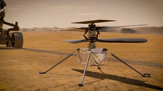
In this era of remote-controlled drone copters being piloted all over our blue-green atmosphere, the Perseverance, which was assembled under the systems integration of the Seattle company known as First Mode, can also launch a helicopter of its own from inside the belly of the rover.

The historic search for life on Mars begins with the study of geologic specimens. As a key member of First Mode — a creative powerhouse of design, engineering, and scientific talent — Kathleen Hoza, a systems engineer and geologist, was responsible for creating the first 2D analysis tool for this purpose, a prototype device known as a Goniometer, developed while pursuing her M.S. in geology at Western Washington University. The first generation spectral analyzer laid the groundwork for the next breakthrough, 3D device.
“I couldn’t be more excited about continuing to work on this research,” Kathleen said. “The science potential is significant and far-reaching, and we have a powerful combined team with experts from First Mode and Western Washington University.”
With the Perseverance landing on Mars’ Jezero Crater on February 18, we thought this would be the moment to catch up with the Goniometer’s lead engineer and interstellar rock star.
Seattle24x7: What is a Goniometer?
Kathleen Hoza: At its core, a goniometer (pronounced go·ni·om·e·ter) is a fancy name for a tool that either measures an angle or helps position an object at a very precise angle for measurement. If you used a protractor in grade school to measure angles, you used a simple version of a goniometer. When measurements need to be extremely precise, or they need to occur in three dimensions, the instruments tend to get a bit more complicated, but the idea behind them is the same.
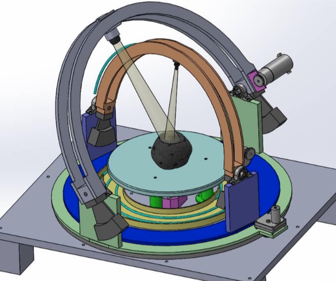
Source: Peter Illsley, First Mode
In this case, First Mode and WWU are building a 3D-goniometer (pictured) to measure rock samples as they would be encountered in the real world (i.e., not prepared as a two-dimensional sample). This particular instrument will allow a few things to occur.
- A light source can be positioned with a high level of accuracy on one of the moveable arcs.
- A detector can be positioned with equal accuracy on the other moveable arc.
- A three-dimensional sample can be inserted into the instrument as-is, rather than a sample that must be prepared or sliced.
When put together, this instrument will enable spectral observations of rock samples at different angles.
Seattle24x7: Why is this work important?
Kathleen Hoza: Fundamentally, geology is science concerned with what we can learn from the rocks, soil, and processes that form any terrestrial planet or natural satellite, including Earth, Mars, or the Moon. The more we can learn about the composition, age, and history of a rock, the better we can understand past climates, evolutionary history, and even the location of valuable minerals.
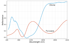
Source: Kathleen Hoza, First Mode
While Earth-based methods of geology include highly precise laboratory techniques, on other planetary bodies, we lack infrastructure such as climate-controlled space, heavy lab equipment, and people on the surface (for now!). Instead, we rely on our robotic emissaries to capture scientific data via their instrumentation and send it back to us here on Earth.
When we take scientific measurements, the details become critical. We are faced with many bold questions as we investigate Mars. Was flowing water present on Mars in the past? Could it have hosted life? What happened to it? In the face of these important questions, we must have a high degree of confidence in the data that informs our answers. It isn’t the kind of thing you want to be wrong about!
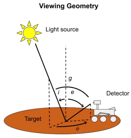
One of those critical details is the viewing geometry (pictured). Measurements of rocks, particularly those that have been weathered over time, are known to be influenced by the angular positioning of the detector (the rover) relative to the target material, but that influence has never been fully quantified. You can think about it like taking a picture with your iPhone — your picture is going to turn out very different as you move, tilt, and interact with your light source (the sun), your subject, and your detector (iPhone).
Once the goniometer is built, it will be used to characterize a representative suite of Martian analog rocks with different compositions, textures, and degrees of alteration. This data will be used by researchers at WWU and NASA to develop a library against which geologists can compare spacecraft data from Mars. The library can help scientists spot subtle variations in measurements and detect key weathering patterns that might otherwise be overlooked.
For example, microns-thick layers of amorphous silica, which could indicate the past presence of water, might not be detectable using standard techniques, but they create observable differences when measurements are taken at different angles.
Seattle24x7: What kind of research will the goniometer help with?

Kathleen Hoza: Spacecraft on other planets use a combination of techniques to tease out information about the composition and structure of rocks. Once we know that information, we can make inferences about the environment and timing of those rocks’ formation, and that can help answer big-picture science questions. For example, we’ve used a technique called reflectance spectroscopy to determine that Mars rocks contain minerals that could only have formed in a long-lasting water-rich environment – exactly the kind that could have supported life. Geological research on other planets can also help us to understand the basic process that form and alter planets, including our own Earth.
Seattle24x7: How does the goniometer help?
Kathleen Hoza: One of the major techniques for studying rocks on other planets is reflectance spectroscopy, which involves measuring energy at specific wavelengths of light that are emitted by the Sun, bounce off rocks, and then enter a detector on the spacecraft. Different rocks absorb and reflect different wavelengths of light, and we can tell them apart based on their specific spectroscopic signatures.
But, in order to understand what we are seeing when a rover takes a measurement on Mars, we have to know what we’re looking for. This means going out into the field on Earth, collecting rocks we think might be similar to Mars (or Moon, or Venus…) rocks, and then taking measurements in a lab on Earth in a way that is very similar to a spacecraft taking a measurement on a different planetary surface. This is called an analog study, and analog studies anchor our understanding of geological measurements taken in space.
In order for these analog studies to be useful, we have to make sure that we are accurately replicating the conditions the spacecraft will experience. ‘

This is where the goniometer comes in. In space, the angular position of the Sun in the sky and the angular position of the detector on the spacecraft relative to the target rock surface can influence the measurement. In the lab, a goniometer lets us carefully position a light source so as to simulate all different times of day, and also to position a detector to simulate all different positions of the spacecraft relative to the surface.
By taking measurements in many different angular positions, we can build up a spectral library that we can use to cross-check against spacecraft measurements. Ultimately, this leads to a better understanding of surface geology, which in turn contributes to the search for past life and the quest to better understand how planets (including Earth) form and evolve.
Seattle24x7: How does the goniometer relate to the Perseverance rover?
Kathleen Hoza: The team working on the goniometer has been collaborating closely with the Perseverance science team (including Prof. Rice, who will be helping to guide rover operations when it lands), and the goniometer has been designed with Perseverance’s instruments, environment, and science goals in mind.
Seattle24x7: What are some of the first rocks the goniometer will characterize?
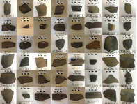
Kathleen Hoza: Once the goniometer arrived at WWU, some of the first rocks it studied came from something called the Mastcam-Z geoboard (https://www.planetary.org/space-images/rock-targets-studied-for-mastcam-cal). This set of rocks was used to help calibrate an instrument on board Perseverance, and measuring these exact same rocks on the goniometer will help us to be certain our measurements are relevant to Perseverance’s measurements on Mars.
Seattle24x7: What is the most exciting thing for you about your work on the goniometer?
Kathleen Hoza: To me, the most exciting part of the goniometer project is how it has brought together incredible people from across different disciplines and situations. The team that’s worked on the goniometer includes scientists, engineers, interns, and students, and every person I’ve had the opportunity to work with has brought something different and valuable to the table. In general, I believe the more we can get people stepping outside their own immediate circles and talking to bright people working in different areas, the more problems we can solve and the better we will do.
Seattle24x7: Now that Perseverance is on Mars, do you have any additional thoughts about the opportunities for geological exploration on the Red Planet?
Kathleen Hoza: Perseverance landed in a site called Jezero Crater, which is an ancient lakebed on Mars. This site was selected for all kinds of excellent reasons, including high potential for preserving signs of past life that we might be able to detect either using Perseverance’s instruments or by caching and collecting samples for return to labs on Earth.
However, the part I’m most excited about will (hopefully) come a few years down the road in Perseverance’s extended mission to a place called NE Syrtis. In NE Syrtis, the ancient “basement” of Mars is exposed, and we will have the opportunity to directly study primary crust, the very first rocks that formed from Mars’ primordial magma ocean. Studying NE Syrtis could lead to entirely new insights into what young planets look like and how they change.
Where do we go from here?
Chris Voorhees, President and Chief Engineer of First Mode, put it in perspective. “As we prepare for further surface missions, including the Mars 2020 Rover and Mars Sample Return, a solid base of scientific research and understanding is essential in getting the most from our robotic systems.
“In addition to space applications, the geological research could be relevant to other First Mode clients and partners in the natural resources industry. “The problems we like the most cross industry boundaries. By drawing from our team’s experience in geology, automation, and the mining and metals industry, we can create a better tool for deep space exploration,” Voorhees commented. “We’re also pleased to share that after development, the entire goniometer design and software package will be publicly released.” [24×7]


 ranks Seattle #1 for Top Wa. Berths")